Toxic Road Salt: Flawed bridges
plan puts east end bridge route
over LWC drinking water intake
© 2011 Louisville, KY Bud Hixson

Toxic Road Salt: Flawed bridges
plan puts east end bridge route
over LWC drinking water intake
© 2011 Louisville, KY Bud Hixson
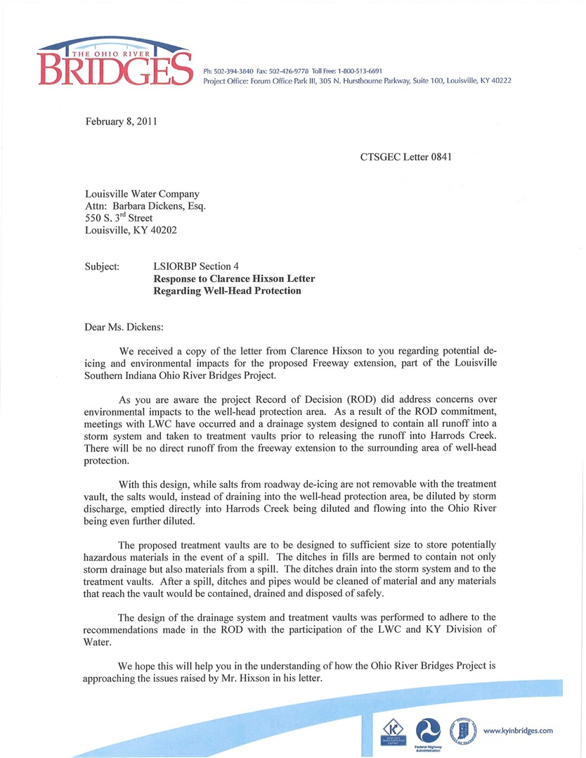
Bridges Authority Consultant Project Manager responds to badwaterjournal with summary of stormwater containment.
Scroll to bottom of page
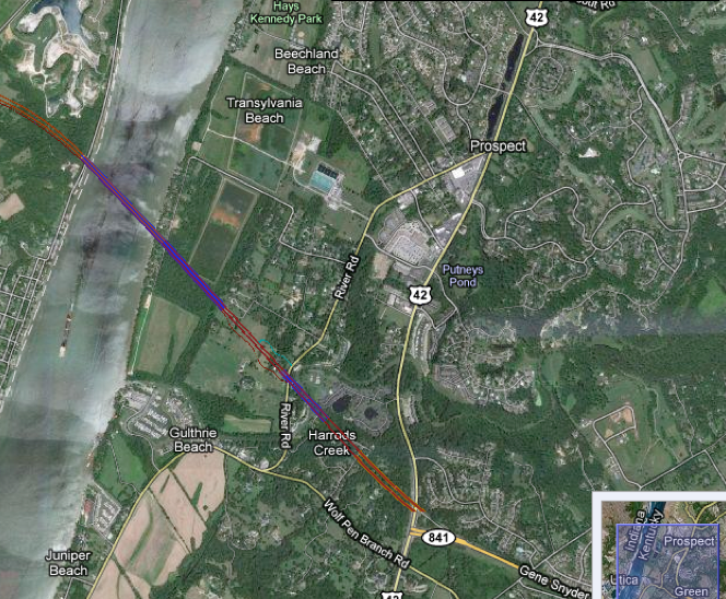
Plans filed and made public by engineers show the proposed route of an East End bridge to be constructed near Prospect, Kentucky, show a route that passes right over the well head protection area of the Louisville Water Company’s $ 55 million dollar Riverbank filtration system of connected artesian wells.
A six lane superhighway passing over a ground water protection zone would result in toxic pollution of the groundwater by automobile storm water runoff. De-icing chemicals would also pollute the groundwater if applied by the tons as the Metro Department of Public Works applies it in Jefferson County.
In December the author requested to view public records from the Louisville Water Company related to any study of the possible pollution from the east end bridge route. The following letter is the author’s response to those records and a call for more public information.
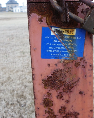
Groundwater test results from Zorn Avenue
groundwater monitoring wells--like the one shown in the photo to the right--show high levels of chloride contamination. See results obtained by Open Records request from Louisville Water Company below.
Louisville Water Company
Barbara Dickens, Esq.
Vice President, General Counsel
& Official Custodian of Records
Beverly Soice
Re: Open Records Request 12-27-2010
by email and letter
Copy to:
John Sacksteder, Project Manager
Community Transportation Solutions
General Engineering Consultant (CTS-GEC)
Forum Office Park III
305 N. Hurstbourne Parkway, Suite 100
Louisville, KY 40222
DEP Division of Water
200 Fair Oaks Lane
Fourth Floor
Frankfort, KY 40601
Ted Pullen
Metro Public Works & Assets
444 South Fifth Street
Suite 400
Louisville, KY 40202
Beverly Soice,
Thanks for your courteous response to my Open Records Request. This is a follow up
memo to our appointment, 1-14-2011 at 2:00 pm in the Kentucky River Room. Please forgive
this long post, but I need to set forth my concerns/request with some supporting documentation.
The materials provided to me so far do not establish that the Louisville Water Company
has quantified or projected the effect of groundwater contamination that will be caused by a proposed east end bridge along the A-15 route identified in the 2003 Rule Of Decision for the Bridges Project.
The materials do not indicate that LWC is taking sufficient action to protect groundwater in the WHPA from deicing contamination.
As such, it appears Louisville political leaders and citizens are not being fully and accurately informed
about the threat of road salt salinization of the ground water resources that are critical supply for Louisville's
drinking water intake at the $55 million dollar artesian well collections area. Without full and complete information the public and decision makers could elect to place a six lane highway and bridge over the wellhead protection area resulting in the contamination and loss of the drinking water source and waste of $ 55 million dollars invested.
You represented at the meeting in the Kentucky Room that LWC had no groundwater protection monitoring chloride results from the Well head protection area, the WPA zones at the Payne collection area.
You provided copies of Na+ and chloride results for testing performed from 2006 to 2008 at the Zorn Avenue facility.
Examination of that data shows a cumulative increase over the testing period, at water monitoring wells designated ZMW-9A, 9B, 9C. At ZMW-9A.
Chlorides increased over the period September 2006 to March 2008, from 4900 mg/L to 8700 mg/L.
"There is no maximum contaminant level (MCL) or health advisory level for sodium; however, there is a
Drinking Water Equivalent Level of 20 mg/L (a non-enforceable guidance level considered protective against
non-carcinogenic adverse health effects). Chloride, for which EPA has established a national secondary drinking water standard of 250 mg/L, adds a salty taste to water and corrodes pipes. It can also cause problems with coagulation processes in water treatment plants. The water quality standard for chloride is 230 mg/L, based on toxicity to aquatic life."
Source Water Protection Practices Bulletin, Managing Highway Deicing to Prevent Contamination of DrinkingWater, USEPA, EPA 816-F-09-008 July 2009, Office of Water (4606).
I was not provided a location for the Zorn ZMW 9A site but I assume it was close to River Road intersection and sensitive to road salt runoff. Does your staff have another interpretation? These Chloride concentrations exceeded U.S. Environmental Protection Agency (USEPA) acute (860 mg/L) and chronic (230 mg/L) water-quality criteria.
Thus the data provided tend to support the scientific peer reviewed literature that,
"Studies have shown that road salts can accumulate in streams and ground water, persisting beyond the time of application, often into the summer months."
"The scientists have found that salt levels (chloride and sodium) at Minebank Run are chronically elevated throughout the year, even in summer when no salts are applied. Chloride and sodium levels are significantly higher downstream of the I-695 beltway, suggesting that this major roadway is a significant source of road salts to ground and surface water in this watershed."
http://www.epa.gov/ada/eco/pdfs/road_salts.pdf
and,
"The relation of chloride concentrations and specific conductance with urban land use shown in this study and a recent study of the northern United States (23) indicates that road-salt runoff and other anthropogenic uses of chloride are importantfactors in the biological integrity of urban streams in the northern United States. Although chloride sampling has beenincluded in previous evaluations of urban streamwater quality (21), water-quality sampling did not specifically focus onperiods of winter runoff and may not fully represent the severity of road-salt influence."
Steven Corsi, et al., A Fresh Look at Road Salt: Aquatic Toxicity and Water-Quality Impacts
on Local, Regional, and National Scales, Environmental Science and Technology, 2010, 44, 7376–7382. ACS.
This data is of particular concern to protectors of surface water quality in Beargrass Creek if
LWC intends to discharge FILTER BACKWASH at I-64 and Grinstead Drive to the Middle Fork of Beargrass Creek.
The removal of solids from Zorn Avenue pumped water, whether derived from the artesian collection wells or from the Zorn Avenue River intakes would apparently leave a filtrate high in chlorides.
DATA PROVIDED
The sole document provided to me that directly referred to the object of my Open Records request was titled,
"Proposed Transportation Management Plan" on Page 10 it reads,
"Additional Transportation Issues"
"Additional Transportation Issues include the design and drainage plan for the bridge and tunnel to be constructed over the Ohio River, at least part of which will be located within the WHPA (well head protection area). At this time, details of the design for these structures are not available. LWC plans to meet with the state highway department and design engineers to discuss methods of minimizing the potential for contamination as the design progresses. The local Planning Team will be a part of this planning process."
This laconic item is not dated and appears to be an excerpt from a newer document after the 2003 - 2004 dates of the Wellhead Protection Plan.
Construction of the LWC Riverbank Filtration Project began in March 2007 and was complete in the fall of 2010. The $55 million dollar investment has constructed a system that can pump up to 70 million gallons of water a day from the aquifer.
<http://www.louisvilleky.gov/LWC/News/2010/Riverbank+Filtration+Project+Completed.htm>
This tremendous drinking water supply feat of engineering deserves better protection than a sleepy note that LWC plans to meet with Transportation Dept engineers to discuss minimizing potential contamination. When would that occur?
There is no statement from any qualified engineer or investigator, that a six lane superhighway is even compatible with a 70 million gallon per day drinking water well head area.
The Riverbank Filtration Project was installed after the 2003 ROD of the bridges project, and after the 2003-2004 Wellhead Protection Plan filed with the Groundwater Branch of the Division of Water.
DIFFERENCE IN WITHDRAWAL RATES USED FOR MAPS AND ACTUAL WITHDRAWAL
The 70 million gallon per day pumping rate does not seem to be a rate used by the ground water protection and well head protection plans filed with the state which show a 17 million gallon per day pump rate. The WHPP does not contain any information that the Riverbank Project could draw 70 million gallons per day. There is no indication that the community or the Planning Area Team was ever informed of corrected WHPA maps calculated to show correct areas that would result from a 70 million gallon per day draw down rate. As a result, contamination by salinity from road runoff may occur at a faster rate than indicated.
A map of the proposed route from the website <http://www.kyinbridges.com/maps-features/default.aspx?ml=4> shows the proposed route of the A-15 bridge passing directly over the wellhead protection area.
The Record of Decision discussion of the impacts to groundwater in the well head protection area is vague and unfocused as it did not contemplate the 70 million gallon per day draw down.
Nowhere is there a detailed calculation of pollutant loadings to storm water runoff from deicing practices in the wellhead area.
Engineers projected 72,000 vehicles per day of traffic (or more) on the east end bridge alternative. The wellhead protection plan would seem to require new expert opinion and investigation aimed at answering the question:
How many years before bridge and highway pollution forces the LWC to shut down the $ 55 million dollar Riverbank Filtration wells. Since the wells are linked by a tunnel, the output of the wells would be contaminated even if only the one closest to the bridge began to experience heavy chloride or cyanide pollution. The odds of catastrophic contamination from toxic or hazardous chemicals hauled on the 841 connector bridge are not considered.
Neither the Kentucky Transportation Cabinet, nor the Kentucky Division of Water has the same investment of public money in drinking water facilities impacted by the proposed east end bridge over the WHPA.
The transfer of information from your science community to the public and decision makers is failing to fully describe the impact of road salting on drinking water resources and surface water quality.
Please increase the information on your website to communicate this issue and the present THREAT to the community based on your results.
Clarence Hixson
LWC Data - Test results at Zorn Avenue groundwater test wells ZMW-9A, 9B, 9C
9-19-06 Na(mg/L) Chloride (mg/L)
ZMW-9A 2900 4900
ZMW-9B 1700 2700
ZMW-9C 1600 2600
9-29-06 Na(mg/L) Chloride (mg/L)
ZMW-9A 3700 5100
ZMW-9B 1700 2800
ZMW-9C 1500 2500
10-4-06 Na(mg/L) Chloride (mg/L)
ZMW-9A 2800 5000
ZMW-9B 1800 3100
ZMW-9C 1600 2400
11-14-06 Na(mg/L) Chloride (mg/L)
ZMW-9A 3200 5300
ZMW-9B 1600 2900
ZMW-9C 1300 2400
12-13-06 Na(mg/L) Chloride (mg/L)
ZMW-9A 6900 5800
ZMW-9B 1600 2900
ZMW-9C 2800 2100
1-10-07 Na(mg/L) Chloride (mg/L)
ZMW-9A 3500 6000
ZMW-9B 1900 3000
ZMW-9C 1100 1800
2-14-07 Na(mg/L) Chloride (mg/L)
ZMW-9A 7400 6100
ZMW-9B 4300 2600
ZMW-9C 1600 2000
3-13-07 Na(mg/L) Chloride (mg/L)
ZMW-9A 3700 6800
ZMW-9B 1700 3000
ZMW-9C 1200 2100
4-10-07 Na(mg/L) Chloride (mg/L)
ZMW-9A 4000 7000
ZMW-9B 1800 3100
ZMW-9C 1300 2400
5-15-07 Na(mg/L) Chloride (mg/L)
ZMW-9A 4400 7500
ZMW-9B 1800 3000
ZMW-9C 1300 1800
6-13-07 Na(mg/L) Chloride (mg/L)
ZMW-9A 4700 7600
ZMW-9B 1900 3200
ZMW-9C 1000 1800
7-12-07 Na(mg/L) Chloride (mg/L)
ZMW-9A 4000 7100
ZMW-9B 2000 3000
ZMW-9C 1000 1700
8-14-07 Na(mg/L) Chloride (mg/L)
ZMW-9A 4300 7700
ZMW-9B 430 3600
ZMW-9C 210 1700
DATA GAP
3-24-08 Na(mg/L) Chloride (mg/L)
ZMW-9A 4900 8700
ZMW-9B 2400 4200
ZMW-9C 1600 3000
Rule of Decision
LWC website
http://www.louisvilleky.gov/LWC/News/2010/Riverbank+Filtration+Project+Completed.htm
World Class Innovation
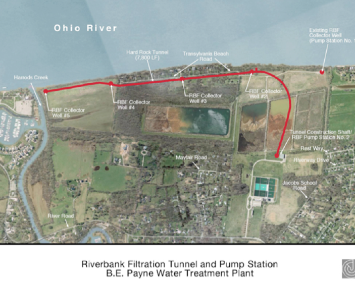
The project is unique because Louisville Water is the first water utility in the world to combine a gravity tunnel with wells as a source for drinking water.
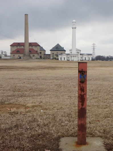
Louisville Water designed and constructed a mile-and-half-long tunnel in bedrock, 150 feet below the ground surface. The tunnel is parallel to the Ohio River at the company’s B.E. Payne Treatment Plant. Four wells were sunk to collect the ground water and send to the tunnel. A pump station pulls the water from the tunnel and into the treatment plant. Louisville Water can pump up to 70 million gallons of water a day from the aquifer.
Louisville Water began Riverbank Filtration in 1999 with a 15 million gallon per day test well. Extensive water quality research and testing occurred over the first several years of its operation to verify the water quality and the replenishment of the water table. Based on the success, Louisville Water expanded the project to include four additional wells, a tunnel and pump station. The tunnel minimizes the above-ground impact. The wells are capped at the ground and only the pump station at the B.E. Payne Plant is visible above-ground.
A Green Supply
There are several advantages to Riverbank Filtration. Because the water is cleaner, it requires less treatment. The process eliminates taste and odor issues, provides an additional barrier for pathogen removal and creates a stable water temperature of around 55-degrees, resulting in fewer main breaks in the distribution system.
Design and Construction
Construction began in March 2007 and was complete in the fall of 2010. The $55 million dollar investment was funded through Louisville Water’s capital budget. Jordan Jones & Goulding provided engineering and design. Mole Constructors, Inc. was awarded the bid for construction of the tunnel and pump station.
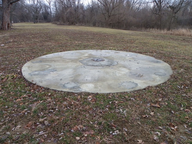
No groundwater monitoring well test results have been obtained from the Louisville Water Company for the wellhead protection area in Prospect around the Riverbank Filtration Project. Shown here is the concrete cap of collector well N0. 3. The bridge approach appears to pass 50 yards south of this well. See the layout site map below provided by Louisville Water Company.
The potential for groundwater contamination is increased by large shopping center parking lots and developments in the wellhead protection area as well as a KPDES permitted barge washing facility just across the river. Wellhead protection area signage has not been installed as depicted in the wellhead protection plan filed with the state.

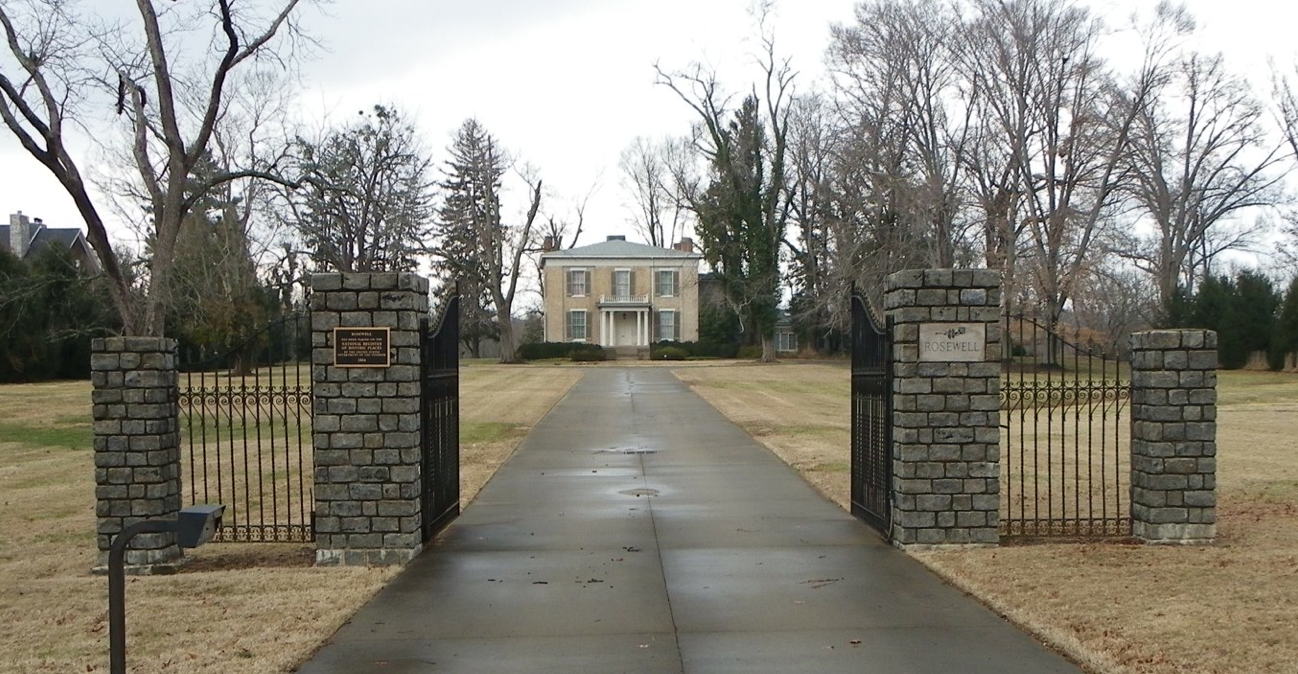
Above: Historic Rosewell estate near the proposed crossing of the East End Bridge
The Community Transportations Solutions Consultant response did not include an offer to inspect records showing calculated loadings of chloride pollution from the bridge runoff. In addition discharging the polluted runoff during winter deicing conditions would ADD to high chloride concentrations already in Harrods Creek --not be diluted by Harrods Creek.
A further request 2-9-2011 has been submitted for records:
John Sacksteder, PE
Project Manager
Community Transportation Solutions -
General Engineering Consultant
Louisville - Southern Indiana Ohio
River Bridges Project
305 N. Hurstbourne Lane, Suite 100
Louisville, KY 40223
RECORDS REQUEST pursuant to
401 KAR 5:037 Section 7, and KRS 61.872(2) Open Records
These records will not be used for a commercial purpose, but may be included in articles
written for the <http://www.badwaterjournal.com> website --a non-commercial blogsite.
Dear Mr. Sacksteder,
Thank you for your courteous response, received by email 2-9-2011.
I am requesting to see the design drawings of the bridge approach runoff containment system including the nature and construction of surface ditches or underground pipes, how they are routed and where they go. Since the Bridges Authority and KYDOT will be discharging deicing materials above the WHPA at the East End Bridge site, a groundwater protection plan should be required thatwill contain the requested information.
I am particularly interested in the design and performance specs for the storm runoff
"treatment vaults." I don't think any of this has been shared with any public consultation group--I cannot find any such record. Alternatives to using road salt deicing do not appear to have been considered and your response does not indicate that protection of Harrods Creek extends to calculating the expected chloride concentration of such a discharge from a point source storm water outlet.
Such a discharge would likely exceed 4000-6000 mg/L chloride under winter road salt deicing conditions. Can you address this calculation specifically? The chloride and heavy metal contaminated road runoff would apparently go to detention ponds first, I glean from your response. The location of these ponds relative to the well head protection area is not shown. Will the ponds be lined?
To be clear, I am requesting to view or copies of records:
1) I request to see a detailed location map and engineering drawings that
show the storm water containment system, ponds and treatment vaults
2) I request to see the proposed discharge point to Harrods Creek and any calculated
chloride and metal concentrations for the deicing applied, including the road dust contaminants
of the expected traffic volume in expected winter deicing and runoff storms.
3) I request to see engineering studies calculating locations of detention and discharge
and demonstrating no contamination of the WHPA. Also, the similar studies for bridge
construction pilings and other construction disturbing the area above the WHPA.
My request is not for a few paragraphs of summary from the leadership, but to see records of
engineering drawings and scientific consultations showing that the Bridge Authority has
already commissioned and paid for an accurate calculation of the pollution loadings
that will be generated above the WHPA and has evolved a practical and properly conceived plan to contain and treat maximum expected loadings to protect the water quality --both ground and surface water. If your system does not contain all storms--pollution of the WHPA will result.
I am requesting you add my name to any list receiving notice of meetings of public consultation
of the East End Bridge and WHPA groundwater protection plans.
Thank you for your attention and efforts,
Clarence H. Hixson